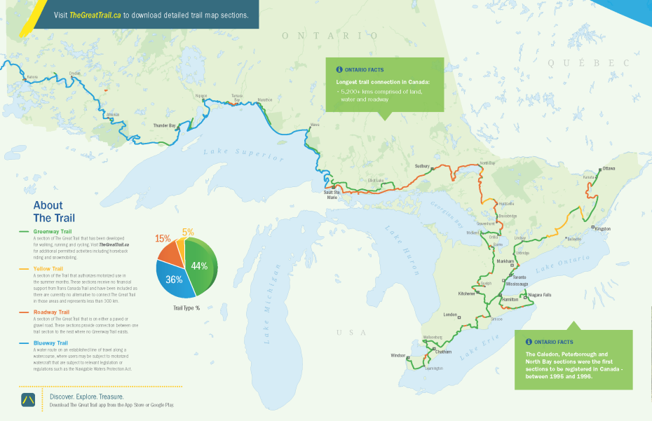
View our summary of the 100+ trail sections in Ontario by region, length and trail maintenace contact.
Southwestern Ontario
Niagara
Hamilton Halton Brant
Huron Perth Waterloo Wellington
Toronto
York Durham Headwaters
Grey Bruce Simcoe
Kawarthas Northumberland
Southeastern Ontario
Ottawa
Ontario’s Highlands
Explorer’s Edge
Northern Ontario
Visit http://www.thegreattrail.ca for step-by-step routes or download The Great Trail App available for Android & iOs
Southwestern Ontario
https://www.ontariossouthwest.com/
Trail Name |
Length |
Trail Maintenance |
Trail Information & Map |
Niagara
https://www.visitniagaracanada.com/
Trail Name |
Length |
Trail Maintenance |
Trail Information & Map |
| Chippawa Rail Trail | 18.86 KM | Conservation Hamilton | http://conservationhamilton.ca/trans-canada-trail-2/ |
| Friendship Trail – Fort Erie | 17.01 KM | Town of Fort Erie | http://www.forterie.ca/pages/RecreationalTrails |
| Friendship Trail – Port Colborne | 16.68 KM | City of Port Colborne | http://portcolborne.ca/fileBin/library/Port%20Colborne%20Cycling%20Map%2027-2reduced.pdf |
| Gord Harry Trail | 12.11 KM | Niagara Peninsula Conservation Authority 905-892-1736 | https://npca.ca/conservation-areas/gord-harry-trail |
| Niagara River Recreation Pathway | 57.18 KM | The Niagara Parks Commission | https://www.niagarafallstourism.com/play/outdoor-recreation/the-niagara-river-recreation-trail/ |
| Laura Secord Legacy Trail | 32.87 KM | Friends of Laura Secord | http://www.friendsoflaurasecord.com |
Hamilton Halton Brant
Trail Name |
Length |
Trail Maintenance |
Trail Information & Map |
| Trans Canada Trail – Hamilton Trail System | 36.11 KM | City of Hamilton | http://www.map.hamilton.ca/Static/PDFs/Public%20Works/Bikeways%20Map%20-%20March_2015%20-%20URBAN_optimized.pdf |
| Gordon Glaves Memorial Pathway | 13.06 KM | City of Brantford 519-756-1500 | http://www.brantford.ca/Parks%20and%20Trails%20%20Documents/City%20of%20Brantford%20Trail%20Map%202014.pdf |
| Hamilton to Brantford Rail Trail | 33.21 KM | ||
| TH & B Rail Trail | 20 KM | County of Brant 519-442-1818 | http://www.brant.ca/en/discover-brant/resources/THB_LEN.pdf |
| SC Johnson Trail | 13.63 KM | Grand River Conservation Authority 1-866-900-4722 | https://www.grandriver.ca/en/outdoor-recreation/SC-Johnson-Trail.aspx |
Huron Perth Waterloo Wellington
https://www.ontariotravel.net/en/explore/huron-perth-waterloo-and-wellington
Trail Name |
Length |
Trail Maintenance |
Trail Information & Map |
| Cambridge to Paris Rail Trail | 19.22 KM | ||
| Cottontail Road Trail | 16.26 KM | County of Wellington 519-837-2600 | http://www.wellington.ca/en/discover/Cottontail-Road-Trail.asp |
| Cruickston Trail | 1.9 KM | Cambridge Trails (519) 740-4681 ext. 4275 | https://www.cambridge.ca/en/parks-recreation-culture/Trails-List.aspx |
| Elora Cataract Trailway | 47.73 KM | http://trailway.org/ | |
| Fountain Street | 1.37 KM | ||
| Grand Trunk Trail | 3.69 KM | Cambridge Trails (519) 740-4681 ext. 4275 | https://www.cambridge.ca/en/parks-recreation-culture/resources/Grand-Trunk-Trail-Brochure_Final.pdf |
| Guelph Trans Canada Trail | 5.39 KM | http://guelph.ca/living/recreation/parks/trails/ | |
| Iron Horse Trail | 5.74 KM | City of Waterloo | http://www.waterloo.ca/en/gettingactive/ironhorsetrail.asp |
| Wellesley Township Trans Canada Trail | 6.62 KM | Township of Wellesley 519-699-4611 | http://www.wellesley.ca |
| Woolwich Township Trans Canada Trail | 13.23 KM | Woolwich Township 1-877-969-0094 | http://www.woolwich.ca/en/discover-us/Parks-and-Trails.aspx |
| Living Levee Trail | 2.4 KM | Cambridge Trails (519) 740-4681 ext. 4275 | http://www.visitcambridgeontario.com/Trails.htm |
| Schneider Creek Trail – Homer Watson Trail | 11.31 KM | ||
| Laurel Trail | 9.45 KM | Region of Waterloo | http://www.waterloo.ca/en/gettingactive/laureltrail.asp |
| Kissing Bridge Trailway | 29.18 KM | http://www.kissingbridgetrailway.ca/ | |
| Blair Trail | 0.64 KM | Cambridge Trails (519) 740-4681 ext. 4275 | https://www.cambridge.ca/en/parks-recreation-culture/Trails-List.aspx |
Toronto
Trail Name |
Length |
Trail Maintenance |
Trail Information & Map |
| Waterfront Trail | 86.66 KM | Waterfront Regeneration Trust (416) 943-8080 | http://www.waterfronttrail.org/ |
| Pan Am Path | 40.42 KM | http://www.panampath.org | |
| UFT / Ryerson Connector | 4.65 KM |
York Durham Headwaters
http://yorkdurhamheadwaters.ca/
Trail Name |
Length |
Trail Maintenance |
Trail Information & Map |
| Caledon Trail Link | 10.94 KM | Parks & Recreation at the Town of Caledon 905-584-2272 x 4235 | http://www.caledon.ca/en/tourism/resources/map-Explore-Caledon.pdf |
| Caledon Trailway | 26.05 KM | http://www.caledon.ca/en/tourism/resources/map-Explore-Caledon.pdf | |
| Durham Region Trans Canada Trail | 93.64 KM | Durham Region 1-800-372-1102 | https://www.durhamtourism.ca |
Grey Bruce Simcoe
Trail Name |
Length |
Trail Maintenance |
Trail Information & Map |
Kawarthas Northumberland
http://kawarthasnorthumberland.ca/
Trail Name |
Length |
Trail Maintenance |
Trail Information & Map |
| Campbellford Trans Canada Trail | 33.54 KM | Eastern Ontario Trails Alliance 877-889-8810. | http://www.thetrail.ca |
| Kawartha Trans Canada Trail | 54.15 KM | Kawartha Trans Canada Trail Association http://www.ktct.ca | http://www.ktct.ca |
| Jackson Creek Kiwanis Trail | 4.71 KM | Otonabee Conservation Centre (705) 745-5791 | http://www.peterborough.ca/Living/Recreation/Free_in_Peterborough/Parks___Trails.htm |
| Peterborough Trans Canada Trail | 7.07 KM | City of Peterborough | http://www.peterborough.ca/Living/Recreation/Free_in_Peterborough/Parks___Trails.htm |
| Lang Hastings Trail | 32.41 KM | Peterborough Hastings Trans Canada Trail Association | https://www.facebook.com/PHTCTA/ |
Southeastern Ontario
Trail Name |
Length |
Trail Maintenance |
Trail Information & Map |
| Cataraqui Trail | 80.99 KM | Cataraqui Trail Management Board (CTMB) | http://cataraquitrail.ca/ |
| Brouwers Line | 4.42 KM | http://www.elgintourist.com/play/outdoor-recreation | |
| Elgin Trans Canada Trail | 19.09 KM | Contact Elgin County 519-631-1460 | http://www.railwaycitytourism.com/trails.html |
Ottawa
Trail Name |
Length |
Trail Maintenance |
Trail Information & Map |
| Capital Pathway | 25.4 KM | Contact the National Capital Commission 613-239-5000 | http://www.ncc-ccn.gc.ca/sites/default/files/pubs/ncc_cycling_map_2016-optimized.pdf |
| Ottawa To Carleton Trailway | 23.2 KM | ||
| Rideau Hall | 1.2 KM |
Ontario’s Highlands
Trail Name |
Length |
Trail Maintenance |
Trail Information & Map |
| Carleton Place Trailway | 7.77 KM | Town of Carleton Place 613-257-6200 | http://www.cgis.com/cpal/?map=Lanark |
| Central Frontenac Trailway | 35.75 KM | This portion of the Trail is managed by the Eastern Ontario Trails Alliance and can be contacted at 877-889-8810. | http://www.frontenaccounty.ca/en/corporate/trails.asp |
| Frontenac K&P Trail | 45.88 KM | County of Frontenac | http://www.frontenacmaps.ca/tour/ |
| Hastings County | 65.61 KM | This portion of the Trail is managed by the Eastern Ontario Trails Alliance and can be contacted at 877-889-8810. | https://www.thetrail.ca/ |
| Kaladar Trail | 16.65 KM | This portion of the Trail is managed by the Eastern Ontario Trails Alliance and can be contacted at 877-889-8810. | https://www.thetrail.ca/ |
| Lanark Link | 105.7 KM | Lanark County | http://lanarkcountytourism.com/ |
Explorer’s Edge
Trail Name |
Length |
Trail Maintenance |
Trail Information & Map |
| Ramara Washago Greenway Connection | 15.01 KM | ||
| Washago to Coopers Falls Connector | 14.39 KM | ||
| Bracebridge Trans Canada Trail | 26.96 KM | Muskoka Trails Council | http://mtc.mosaicmediagroup.com/files/PDFs/Trails/Bracebridge/bracebridge_transcan.pdf |
| Gravenhurst Trans Canada Trail | 49.28 KM | Call (705) 687-9424 | https://icreate5.esolutionsgroup.ca/230886_Gravenhurst/en/discoverus/resources/coopersfalls_trail.jpg |
| Huntsville Trans Canada Trail | 51.8 KM | Town of Huntsville 705-789-1751 | http://www.huntsville.ca/en/living/trails.asp |
| Park to Park Trail | 3.97 KM | http://www.parktoparktrail.org/ | |
| Seguin Trail | 32.04 KM | Contact the Park to Park Trail Association 1 (888) 213-8134 x 26 | http://www.parktoparktrail.org/ |
| Perry Township Trans Canada Trail | 5.72 KM | http://www.townshipofperry.ca/ | |
| Old Nipissing Road | 79.72 KM | Contact Discovery Routes (705) 472-8480 | http://www.nipissingroad.ca/ |
Northern Ontario
http://www.northernontario.travel/
Trail Name |
Length |
Trail Maintenance |
Trail Information & Map |
| Fisher Wavy Trail | http://www.rainbowroutes.com/fisher-wavy-trail-jcwp-tct/ | ||
| Jean Tellier Trail | http://www.rainbowroutes.com/jean-tellier-trail-tct/ | ||
| Martindale to Downtown | 4.5 KM | http://www.rainbowroutes.com/martindale-to-downtown/ | |
| Lake Laurentian Conservation Area to Moonlight Beach | http://www.rainbowroutes.com/lake-laurentian-conservation-area-to-moonlight-beach-tct/ | ||
| Hillfield Trail | http://www.rainbowroutes.com/hillfield-trail-tct/ | ||
| Callander Trail to Kate Pace Way | 12.31 KM | Contact Discovery Routes (705) 472-8480 | http://discoveryroutes.ca/north-bay/kate-pace/ |
| Bell Park Walkway – Jim Gordon Boardwalk | 1.91 KM | http://www.rainbowroutes.com/bell-park-pathway-tct/ | |
| Bethel Lake Trail | 1.42 KM | http://www.rainbowroutes.com/bethel-lake-trail-tct/ | |
| Callander Trail | 9.07 KM | Contact Discovery Routes (705) 472-8480 | http://discoveryroutes.ca/callander/ |
| Pat Haufe Way | 38.74 KM | Contact Discovery Routes (705) 472-8480 | http://discoveryroutes.ca/ |
| Greater Sudbury Trail East | 28.99 KM | Contact the City of Greater Sudbury 705-671-2489 or 311 | https://static1.squarespace.com/static/577a997215d5db17f979fe0c/t/5788f2772994ca7e84a2530a/1468592763134/rainbow+routes+map+2015.pdf |
| Greater Sudbury Area West | 26.3 KM | Contact the City of Greater Sudbury 705-671-2489 or 311 | https://static1.squarespace.com/static/577a997215d5db17f979fe0c/t/5788f2772994ca7e84a2530a/1468592763134/rainbow+routes+map+2015.pdf |
| Junction Creek Waterway Park | 5.66 KM | http://www.rainbowroutes.com/jcwp/ | |
| Kate Pace Way | 12.35 KM | Contact Discovery Routes (705) 472-8480 | http://discoveryroutes.ca/north-bay/kate-pace/ |
| Ramsey Lake Path | 3.09 KM | http://www.rainbowroutes.com/ramsey-lake-path-tct/ | |
| Kelly Lake Trail | http://www.rainbowroutes.com/kelly-lake-trail-tct/ | ||
| Laurentian University Trail | http://www.rainbowroutes.com/laurentian-university-tct/ | ||
| Vermillion River to Hillfield Trail | http://www.rainbowroutes.com/vermillion-to-hillfield-trail-tct/ | ||
| Sudbury North Bay Trail | 183.53 KM | Contact Discovery Routes (705) 472-8480 | http://discoveryroutes.ca/trans-canada-trail/ |
| Lake Superior Water Trail – LSWT | 989.11 KM | Contact Lake Superior Water Trail (705) 946-0044 | http://www.superiorconservancy.org/ |
| John Rowswell Hub Trail | 54.79 KM | Contact the City of Sault Ste. Marie 705-759-5368 | http://saultstemarie.ca/City-Hall/City-Departments/Community-Development-Enterprise-Services/Planning-Enterprise-Services/Strategic-Long-Range-Planning/Active-Transportation/John-Rowswell-Hub-Trail.aspx |
| Lake Huron North Channel | 381.98 KM | http://www.lhncwaterfronttrail.ca/ | |
| Voyageur Trail – Stokely Creek | 13.1 KM | Contact the Voyageur Trail Association 1-877-393-4003 | http://www.voyageurtrail.ca/ |
| Voyageur Trail – Sault Ste. Marie | 7.17 KM | Contact the Voyageur Trail Association 1-877-393-4003 | http://www.voyageurtrail.ca/ |
| Batchawana Bay | 3.56 KM | Batchawana Bay Provincial Park (705) 882-2209 | https://www.ontarioparks.com/park/batchawanabay/maps |
| Voyageur Trail – Kwewiskaning | 9.96 KM | Contact the Voyageur Trail Association 1-877-393-4003 | http://www.voyageurtrail.ca/ |
| Voyageur Trail – Spanish to Elliot Lake | 81.84 KM | Contact the Voyageur Trail Association 1-877-393-4003 | http://www.voyageurtrail.ca/ |
| Voyageur Trail – Nipigon River | 9.74 KM | Nipigon Township Office 807-887-3135 | http://www.voyageurtrail.ca/ |
| Voyageur Trail – Wawa | 21.1 KM | Contact the Voyageur Trail Association 1-877-393-4003 | http://www.voyageurtrail.ca/ |
| Voyageur Trail – Lake Superior Provincial Park | 61.96 KM | Contact the Voyageur Trail Association 1-877-393-4003 | http://www.voyageurtrail.ca/ |
| Voyageur Trail – Marathon | 21.23 KM | Contact the Voyageur Trail Association 1-877-393-4003 | http://www.voyageurtrail.ca/ |
| Voyageur Trail – Pancake Bay Provincial Park | 5.42 KM | Contact the Voyageur Trail Association 1-877-393-4003 | http://www.voyageurtrail.ca/ |
| Coastal Hiking Trail – Pukaskwa National Park | 57.8 KM | Contact: 807-229-0801 or Glen at 229-2576 | http://www.voyageurtrail.ca/ |
| Voyageur Trail – Goulais River | 16.8 KM | Voyageur Trail Association 1-877-393-4003 | http://www.voyageurtrail.ca/ |
| Voyageur Trail – Elliot Lake to Sault Ste. Marie | 188.49 KM | Contact the Voyageur Trail Association 1-877-393-4003 | http://www.voyageurtrail.ca/ |
| Animikii Trail | 101.35 KM | Path of the Paddle Association | http://www.pathofthepaddleassociation.com/trails |
| Iinoo Oowan Trail | 165.92 KM | Path of the Paddle Association | http://www.pathofthepaddleassociation.com |
| Beaten Path Nordic Trail | 15.11 KM | https://www.facebook.com/Beaten-Path-Nordic-Trails-464432476931308/ | |
| Dryden Trail | 8.63 KM | http://www.dryden.ca/UserFiles/Servers/Server_6/File/GISMaps/DrydenTrailMap.pdf | |
| Kabeyun Trail | 50.34 KM | https://www.ontarioparks.com/park/sleepinggiant | |
| Pigeon River Trail | 63.07 KM | https://www.ontarioparks.com/park/laverendrye | |
| Casque Isles Hiking Trail | 53.07 KM | Contact the Voyageur Trail Association 1-877-393-4003 | http://www.voyageurtrail.ca/ |
| Lake of the Woods Trail | 13.36 KM | http://www.kenora.ca/media/132662/kenora_trailguide_2014_-_final.pdf | |
| Thunder Bay Trail | 50 KM | City of Thunder Bay (807) 625-6195 | http://www.thunderbay.ca/Assets/Living/Recreational+Trails/docs/Thunder+Bay+Trails+Maps+-+North+and+South.pdf |
| Maukinak Trail | 220.83 KM | Path of the Paddle Association | http://www.pathofthepaddleassociation.com/trails |
| Omimi Trail | 150.8 KM | Path of the Paddle Association | http://www.pathofthepaddleassociation.com/trails |
| Quetico Trail | 163.05KM | Path of the Paddle Association | http://www.pathofthepaddleassociation.com/trails |
| Migizi Trail | 255.98 KM | Path of the Paddle Association | http://www.pathofthepaddleassociation.com/trails |
| Pine Tree Pathways | 10.27 KM | http://www.visitmachin.com/PineTree/ | |
| Fort William Historical Site Trail | 1.13 KM | http://fwhp.ca/ | |
| Ignace White Otter Country – IWOC | 11.09 KM |
